
USE SCENARIOS
Real-life application areas of the system:
Creating a Panoramic Image
Sign & Sign Management
Pavement & Road Condition Monitoring

It enables fast, low-cost and high-accuracy collection of physical assets and spatial data in the city.
Pavement & Road Condition Monitoring

Mobile Mapping and Data Management
Manage Your City Without Going to the Streets
Digitize all your field data with high-resolution 360° panoramic images and intelligent POI management.

No Need to Be
on the Field to Observe
From vast agricultural lands to mountainous regions, from post-disaster areas to hard-to-access areas, you can access fast, safe and detailed information without going to the field, thanks to satellite imagery.
By integrating with satellite services like Geolab, Sentinel, Planet, Göktürk, and many others, it offers a rich, high-resolution, competitively priced archive of data from around the world. This allows you to develop fast and reliable solutions for a wide range of applications, including vegetation analysis, urbanization mapping, and post-disaster change monitoring, without having to go into the field.
/ 03
Failure to report damage quickly after a disaster.
/ 03
Plant health, water stress and erosion cannot be tracked on the map.
/ 04
Inability to monitor illegal construction and land use transformations.
/ 02
Inability to detect change with historical images.
/ 01
Inability to perform analysis in large areas without going to the field.
WHAT PROBLEMS DOES IT SOLVE?
To observe
You Don't Have to Be on the Field
From vast agricultural lands to mountainous regions, from post-disaster areas to hard-to-access areas, you can access fast, safe and detailed information without going to the field, thanks to satellite imagery.
By integrating with satellite services like Geolab, Sentinel, Planet, Göktürk, and many others, it offers a rich, high-resolution, competitively priced archive of data from around the world. This allows you to develop fast and reliable solutions for a wide range of applications, including vegetation analysis, urbanization mapping, and post-disaster change monitoring, without having to go into the field.
WHAT PROBLEMS DOES IT SOLVE?
/ 01
Inability to perform analysis in large areas without going to the field.
/ 02
Inability to detect change with historical images.
/ 03
Failure to report damage quickly after a disaster.
/ 04
Inability to monitor illegal construction and land use transformations.
/ 06
Plant health, water stress and erosion cannot be tracked on the map.
HIGHLIGHTS
Monitor Growth, Risk, and Change with Image-Based Tracking

High Resolution Optical Images
Flexible images available in mono and stereo options with a resolution range from 10 m to 25 cm.
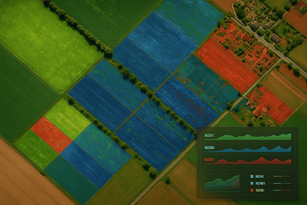
NDVI, NDWI, NDBI and Other Spectral Analyses
Precise spectral analyses for plant health, moisture status and land cover.

SAR Radar Images
Radar images that provide uninterrupted monitoring even in cloud, night and difficult weather conditions.

Land Use and Classification
Changes in data distribution can be monitored according to a specific date range.
.jpg)
Image Processing
Organize images and make them suitable for analysis with basic operations such as mosaicking, orthorectification, and atmospheric correction.

Time Series Change Analysis
Analyses to monitor changes and trends with images from different dates.
WHO SHOULD USE IT?
Ideal and Reliable Solutions for Planning and Monitoring
Agriculture and Environmental Management Institutions
Disaster and Crisis Management Units
Municipality and Urban Planning Teams
Mapping, Engineering and Consulting Companies
Universities and Research Centers
Investment and Project Development Companies


WHAT DOES IT GAIN?
Saves Time with Remote Sensing and Makes It Possible to Foresee Risks
01.
Rapid Observation in Large Areas
It provides the opportunity to analyze tens of thousands of hectares of land in minutes, not days.
02.
Reduces Field Team Costs
Instead of sending a team to every location, analysis is done remotely and securely.
03.
Follows Time-Dependent Change
Construction, destruction or plant development can be measured on a time basis.
04.
Risk Management and Early Intervention
Risk areas are identified before the disaster and the precautionary process is brought forward.
05.
Supports Decision Processes with Information
With visual analysis, managers make quick and verifiable decisions.
USE SCENARIOS
Real-life application areas of the system:
Plant Health Monitoring in Agriculture
Post-Disaster Damage Assessment
Urbanization Monitoring and Illegal Building Detection
Drought and Water Management

Plants in Agriculture
Health Monitoring
Farmers and institutions optimize irrigation, fertilization and spraying plans by monitoring plant development.